SAFESCANNER
• LiDAR – Ouster
• Range – 0.40 mts to 100 mts
• Measurement precision ± 3 cm
• Points – 600,000 points per second,
in 360 degrees of orientation
DB#3 DRONE
• Weight – 5.8 kg
• Dimensions (with props) 83 cm x 83 cm x 45 cm
• Illumination Forward high intensity LEDs
• HD Video/Imagery 1080p to internal memory
• On board Geo-referencing of the PTS
• On board production of the 3D model within 25 min of the scan completion.
• Range UG 150 meters – Line of Sight (LOS)
• 70 meters – Beyond Line Sight (BLOS)
• Battery Chem Lithium Polymer – Rechargeable battery
• Flight Time Up to 25 minute
DEEP TRAXX BUGGY
• Weight 9 kg
• Dimensions (with LiDAR) 78 cm x 54 cm x 55 cm
• Illumination 1000 Lumens – High Intensity LED strips
• HD Video/Imagery Low latency and low light LUX analog FPV
• Camera that is streamed for recording.
• Range + 200 mts
• Battery Lithium Polymer – Rechargeable battery
Unlike other underground drones, SafeSight’s DB3™ Underground Drone Technology was developed in a narrow vein environment. Hardened with the capability to access openings as small as 2m x 2m, the DB3™ accesses most unacceptable spaces that other drones won’t even attempt.
Servicing not only the needs of larger mining environment but smaller mines as well is only one of the many key differentiators in our underground drone platform. Working directly with daily operations, our platform has been optimized to support both safety and productivity. Our DB3™ payload, the SafeScanner™ produces geo-referenced point clouds in under 25 minutes post flight. No need for third party software or other costly additional solutions. From Flight to Site Plan in one simple drag and drop.
The DB3™ has the capability to access tight spaces effectively and produce flight results and mapping immediately. This powerful solution is a safety transforming tool that also significantly impacts the operational efficiency and productivity of the sites that deploy it

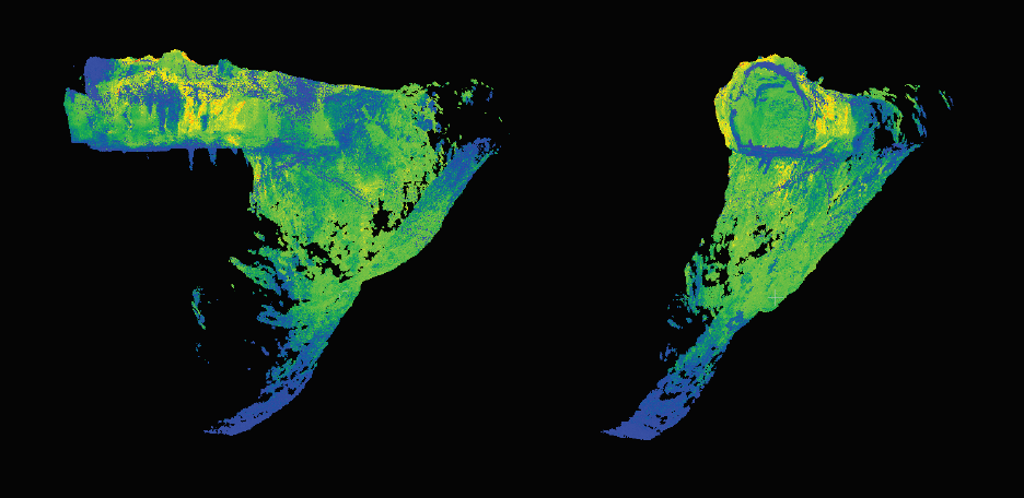
3D MAPPING
The DB3 is equipped with our revolutionary Safescanner payload. With the safe scanner in place the DB3 is able to produce 3-D models of the flight environment on board.
Once the flights complete Safescanner constructs in optimize 3-D modelWith limited to no shadowing. A default PTS format is produce but users can request alternative formats [LAS, DFX, etc )
3-D model production takes between 10 and 25 minutes post flight and can be retrieved from the DB three using a standard USB.
This allows the operator to review results immediately underground or transmit them to surface for analysis and support.

AUTOMATIC GEOREFERENCING
Processing and applying the 3-D mapping Geo reference data from the DB threes safescanner payload requires no third-party software, no additional solution set from Safesight, and knows ongoing service support from our Safesight team
The DB3 SafeScanner payload is a self-contained mapping solution. Capturing the data post flight is only a small component of this highly effective solution.
The DB3 SafeScanner automatically Geo references the point cloud so that it can be easily integrated into site plans to support planning, reconciliation and block modeling. The power of this transformation is completely in your hands to transform your site

PILOT ASSIST
The DB3 comes equipped with a full pilot assist configuration. This allows for the operator to ensure they are always in complete control of the drone at all times while at the same time providing key assistance in accessing tight spaces. Using SafeSight’s autonomous hover and obstacle avoidance features operators can access close proximity flights that allow access into narrow openings unachievable by other underground drones.
These features create ease-of-use while ensuring the operator is always in complete control of the technology

HD VIDEO
The DB3 provides options to gather valuable video data or capture high definition Images and video can be viewed immediately and provide critical information regarding the safety of the environment, the condition of the face and support more effective planning and development.
FAQ
What is the reach of the LiDAR?
The LiDAR has a 100-meter range.
Does the DB3 by autonomously or is it still under operator control when away from the operator’s sight?
Our LiDAR/photogrammetry enabled drone operates in semi autonomous flight mode (autonomous hover, and obstacle avoidance) that remains engaged when beyond line of sight.
How long does the DB3 take to survey a stope?
The complete cycle time, from arriving at the stope, setup, execution of a complete scan and pack up takes – 13min. The actual flight time to capture the stope is about 2 minutes.
It’s important to note that the resulting point cloud (PTS format) is generated on board the drone within about 20 minutes of landing and is ready to import into site planning software.
How long does a battery last? Can batteries be easily changed in the field?
The Batteries are good for 20 min of flight time. Batteries can be regarded in field from 0 to full charge within 1 hour.
What are the DB3’s limiting operating conditions?
We have a risk matrix and Standard Operating Procedure (SOP) that we provide and educate clients on best use cases.
The matrix considers environment and other conditions to determine the safest and most appropriate technology and configuration to capture the scan/data. Our SafeScanner enclosure (the drone payload) can be quickly be set to 4 unique configurations to the best suite the operating environment.
In addition to the default “drone mounted” setting the configurations are designed to meet various conditions, they are:
• Handheld,
• Ground based,
• Cabled,
• Dron.
What is the storage capacity of the drone memory? How much space does the survey of a stope take?
Storage Capacity is 500GB, our drone when scanning captures about .75GB for every minute of flight.
So there is ample capacity to capture and process multiple scans onboard.
What must be done to geo-reference the drone?
Our Drone has in field geo referencing – using our Ground Control App the known survey points at the stope or Landing Zone are entered into the tablet application and the point cloud is auto referenced onboard the drone.
Once complete post flight the surveyor can export a georeferenced point cloud to a USB and send to surface.


